Wednesday, April 26, 2017

CUSTOM REAR DOOR SCREEN FOR THE AIRSTREAM INTERSTATE

I'll warn you in advance that this can be a tedious and frustrating project.  But with commercially-available Airstream Interstate-compatible screens routinely selling for $350 to $500 (rear doors, Sprinter aftermarket) to $3,000 (Airstream OEM option for the sliding door, per owners who have reported getting cost estimates), you can get through it by reminding yourself of all the money you are saving because you suffered through the aggravation of fighting neodymium magnets in a sewing context.  Because in contrast to the pricey versions, my rear screen version costs about $20, and when I eventually get to the point of making a side screen, it won't be much more than that.

The Mercedes Sprinter van body is curved in three dimensions.  It's not just a flat panel with side-to-side curves.  There is also front-to-back curvature.  For this reason, it's almost bloody impossible to properly fit a screen to it through a process of conventional measuring.  The only sane way I found to tackle this project was to repeatedly fit it step by step.  Here's a general description of my process.

I began by taking a piece of no-see-um netting, available on Amazon for about seven bucks, and physically fitting it to the curb-side door opening, with neodymium dot magnets.  If you look closely at this pic, you can see white pin heads on three sides.  Those are the intended magnet positions that resulted from this initial fitting exercise. 
I should clarify that, for this version 2.0 of my screen, I decided to make a screen for just the one door.  My original plan (and my v. 1.0 prototype) was a full-width screen spanning both doors, but we subsequently added a custom hitch carrier that usually carries a Yeti cooler, blocking the street-side door from opening.  Furthermore, the Yeti side of the van is where my husband sleeps, and he doesn't like sleeping with his door open, whereas I do.  For these reasons, I re-designed this v. 2.0 screen to just cover my side, my door.  This makes for a more manageable crafting project, and it also makes for easier administration of the resulting screen.  For instance, if it starts to rain in the middle of the night, it's much easier to wrangle one door rather than two, in order to shut it quickly, especially when the hitch carrier is in place such that I have the rear step to use for this process.

Onward.
Once I cut the no-see-um shape based on that initial magnet fitting to the door frame, I began cutting side trim pieces out of a common black polyester liner fabric that is available in any fabric store.  During my earlier v. 1.0 screen trials, I found side strips to be essential in discouraging insects.  They tend to follow the light, plus their sense of mammalian exhaled carbon dioxide if they are biting insects.  They will walk all the way to the edge of any given barrier in an attempt to get around it.  If there's no border, they'll walk to the edge of the screen and circumvent it by squeezing underneath.  But if there's a border such as what is shown as being added above, they'll stop there.

I wanted about a 3 inch border, so for the top and center which are straight runs, I cut 8 inch strips, hemmed them on each raw edge, and basically sandwiched (more like taco'd) the no-see-um netting in them.  In other words I folded them into a hemmed V-shape and inserted the edge of the cut no-see-um netting into the fold.

Notice that I transposed onto the resulting fitted trim pieces all the original white pins which mark the magnet locations.  This is essential to sustain the integrity of the fit through this trimming process.  
The heavily-curved side piece took a bit more work to cut properly.
I laid the cut no-see-um netting on the polyester fabric and used it as a template for the first curved cut.
But then, of course, I had to basically trim off the remaining straight edge to create a curved strip of uniform width.  
Then I repeated the process of folding this curved strip in half, hemming each raw edge, and fitting it to the rest of the workpiece.  (Seam ironing at each stage is essential in this process, of course.  If you are a seamstress or seamster, you already know that).
Like this.

Notice how the bottom is still raw.  The final step, once this top section is fully fitted, magnet-ed, and sewn, is to add a solid piece on the bottom to take it all the way down to floor level.  Because we have jack-knife couches, I chose not to run the no-see-um all the way to the floor.  Having a solid fabric across the bottom discourages our dog from getting too engaged with whatever she sees outside beyond this screen.  She's well-behaved but I wanted to restrict her vision in this area so that she would be less inspired to try to push through it.  
Then there's the arduous and curse-producing process of hand-sewing in each magnet.
I used a combination of larger plastic-coated neodymiums that were left over from a previous project, and smaller dot magnets.  The larger ones I placed in areas where there was an abundant width of metal door frame exposed.  Smaller ones were used in tighter areas. 
It's very important to hand-baste in the magnets before the side seams are sewn up.  You have to be able to reach under the pinned trim to do this in the proper order.  Order of operations, in other words.
And then it becomes a real pain in the ass to complete the trim sewing, because the neodymiums will stick to everything - your sewing machine plate and foot, each other, your scissors, your pins, etc.  It takes more patience than any human should be forced to summon.  
For the smaller dot magnets, I took a different approach.  I inserted each intended magnet into the places on the trim pocket where they were supposed to go, but then (this is important) I held them in place by adding a temporary magnet on the OUTside of the fabric.  This basically held them captive in the correct locations and allowed me to hand-baste them securely into place without them sliding around, or flying across the room in response to some attractive piece of nearby metal, as neodymiums tend to do.  
If you choose to try this project, understand that it is best done as an iterative process.  You might not get it exactly right on the first try, but you can always carefully re-open your seams and make adjustments as needed.
For instance, working around the lower door hinge was a pain.  I had to get everything sewn and every other magnet in place before I could determine conclusively where this supplemental magnet, represented by the white pin head, needed to be placed.  That two-pronged door keeper you see folds inward when the door shuts (Edit: There also has to be room to be able to reach in and detach this keeper, if the door is to be folded back to the Sprinter body).  I couldn't have it potentially snagging the screen and yanking it off the door frame, because I was designing this screen to stay in place regardless of whether the door is open or shut.  So I'll carefully open up this section of side seam, slide in and anchor another dot magnet at the pin head location, and close it back up again. 
One thing to keep in mind is that it's important to exploit every anchoring opportunity, because in some places, they are limited by the door mechanics and trim.
For instance on the bottom threshold, our 2006 Sprinter reveals this exposed, recessed bolt.  Sure enough, I positioned a neodymium dot to attach to this bolt to help anchor the bottom edge. 
Here's an illustration of why I chose to use variable magnet sizes.  There's just a tiny piece of exposed metal inward of these door contact points.  Airstream's trim covers up most of that section of the Sprinter van body, and I did not want to remove that trim because its aesthetics are pleasing.  Therefore I didn't have room here to place a wider magnet of any kind and still be able to shut the door with the screen in place.  So there are tiny dot magnets just to the inside left of these contact points. 
Now for a couple of money shots.  If you are meticulous and a person skilled in the textile arts, you can spot a few errors I've made in this design.  But if you make your own screen using methods similar to what I've presented here, I'd suggest not sweating the small stuff.  The screen is black and its trim pieces are also black.  It becomes very difficult to see imperfections and personally, I have so many Interstate projects that I intend to complete that I did not want to devote an excessive amount of time to making this project "perfect".  It's a door screen, not an evening gown.
View from the outside in.  See what I mean?  It doesn't exactly jump out and slap you in the face visually.  Nor is it supposed to.

You can see in the photo above the solid piece I attached to the bottom of the no-see-um section.  I took this pic before I had totally completed the clean-up work on the piece, so I hadn't even ironed that section yet.  You can see the original bolt fold near the no-see-um screen. 
And here's the more important view, which is from the inside out.
Not a perfect execution, but presentable.  
And how does it work in practice?
This week, I tested it after dark in a Gulf of Mexico coastal salt marsh, which of course is mosquito heaven.  It does function as designed.  I had no bug penetration to speak of (the far larger problem remains bugs that follow me into the Interstate when I'm entering the vehicle or when I let the dog out to pee).  
 For more discussion on Airstream Interstate screens in general (pros and cons of various approaches), see this Air Forums thread.

Tuesday, April 25, 2017

SEA RIM STATE PARK AND FOUR NATIONAL WILDLIFE REFUGES

Yet another of my whirlwind tours, this time of the upper Texas coast rather than south Texas, and here are some pics and anecdotal comments.

(1) TRINITY RIVER NATIONAL WILDLIFE REFUGE

With 30 million people in Texas but only 1.8% of Texas land being federally-owned (PDF link), you can bet that, at times, things get a little strange around here.  Every federal installation has serious access pressures and some discretion to enforce its own rules, balancing the wildlife preservation mandate against public interest and pent-up demands of too many people who have too few public spaces available to them.  For that reason, policies are variable and access is unpredictable at best, if it exists at all.
The weirdness starts with Googlemaps, which doesn't even name or label portions of this particular refuge (shown anonymously in green above).  The NWR's web pages are no help, because they simply direct the public to "contact the refuge".  But then of course if you try to "contact the refuge", you'll be hard-pressed to locate anyone.  And then if by some miracle you do locate someone, the answer is often "no".  
We drove up to Trinity NWR to see what we could find, and the answer was a big fat nothing.  That trace on the Googlemap called Camp Road wasn't even a public right of way.  There were signs warning of imminent death if one chose to trespass on private property.  Which had every appearance of being federal land, but let me not go off on that tangent.

So, we decided to leave that one for future sleuthing, and we moved onward to our local coastal jewel, the sure-thing known as...

(2) ANAHUAC NATIONAL WILDLIFE REFUGE.

I blogged about this place last year, and it is a gem.
Shoveler Pond. 
A portion of Shoveler Pond at sunset.  I see lots of mountain majesty on Instagram, but we don't have those kinds of massive natural features on the Gulf Coast.  We have to look for the beauty in little things, like sunset colors. 
I say "we" because this short journey started on a Sunday, and my husband and dog followed behind me.  He had to go to work Monday morning and so did I, but my assignment was in Beaumont Texas rather than near our home base in Houston.  Sometimes we do this.  We travel locally and take two vehicles, and then he leaves when it's time to sleep.  It's imperfect but it's the life of working people.  At least this way, I get to spend time both outdoors and with my loved ones. 
Lily pads in Anahuac.  Lotus, I think.  No mud, no lotus
Anahuac after dark.  Part of my purpose for this jaunt was to test my new rear door bug screen.  More on that in a separate blog post, but what better test for a rear door screen than a huge coastal marsh after dark?  Can you say mosquitoes?
Duckweed in said huge coastal marsh.  I forgot my DSLR so these are all iPhone photos.
Near the marsh overlook (boardwalk).
The boardwalk is all done up with stainless steel screws.  My husband speculates that they cost more than the lumber.  The significance of this will be shown by a contrasting photo below. 
(3) SEA RIM STATE PARK.

It was probably wonderful at one time, before it got obliterated by two major hurricanes (pretty much a direct hit by Rita on September 24, 2005 and then again in 2008 by Ike, the third most costly storm in U.S. history). But right now, it's a hot mess.  The visitor's center is a trailer that doesn't even have access to a septic (the park staff's wastewater drains into a honey pot), and there are no showers.  I don't think I've been in another state park that has no showers.
This is what happens when stainless steel screws are NOT used.  Most of the boards on Sea Rim's boardwalk have broken free and were sliding loosely between their side rails.  It's a beautiful boardwalk but the amount of deferred maintenance was staggering. 
I could tell right away that we were shaping up for a great sunset, though. 
And that would be it, as seen from the beach-side of this state park, rather than the marsh-side.  I have never seen a better Gulf of Mexico sunset. 
I had a paid reservation in the park's small campground - this state park does not allow any form of overflow (some do, some don't - again, it's all about access pressures).  However, once two Labrador retrievers began a bark-a-thon, I high-tailed it outa there, abandoning my paid spot and instead I went to park right on the beach, which was unusually wide and firm at this location, so it made for safe Airstream Interstate parking, all eight thousand pounds of her (that sentence is as long as the section of beach that I had all to myself).
Camper van on fire, at least figuratively.  
Every trip and every destination has pluses and minuses.  This was the plus for this one - I had a good square mile all to myself.
And the sunrise was even better than the sunset.  Here's the first peek above the horizon...
...and here's the Full Monty.
When I woke up, the beach was covered with freshly dead fish that had not been there the evening before.
They all appeared to be the same size and species. 
As soon as the seabirds discovered this windfall, there was a great pandemonium of activity as they gorged themselves.  But I could not get any decent phone pictures.  Birds in far-flung areas are not as tolerant of humans as those in urban areas.  They fly away before you even get remotely close.

Speaking of far-flung areas...
I finally got to test part of my new connectivity improvements.  And I was very pleased!  Those are actual "before" and "after" screengrabs of my iPhone's homepage.  Before I flipped the switch, and after I flipped the switch.  Thanks to Technomadia for that one!
(4) McFADDIN NATIONAL WILDLIFE REFUGE
(5) TEXAS POINT NATIONAL WILDLIFE REFUGE.

I did manage to speak to a human at their joint headquarters, and he was quite nice in explaining the management principles that apply to both refuges, and the reasons behind those decisions.  Which gave me some ideas for state and federal policy suggestions.  Which I will discuss in another blog post in the future.
Much of McFaddin looks pretty much like this.  These refuges are largely set-asides for migrating birds.  
Another shot of McFaddin, with bugs squashed on my windshield for special effect.  
Neither refuge had any real pedestrian access.  They are mostly geared toward hunters and fishermen.
Texas Point had a short woodland trail.  Plenty of these were blooming.  They appear as if they might be a coastal rose species (based on what I know of wild roses that grow in Nova Scotia), although they did not smell like roses.  
My main aspiration when I go to an unpopulated area is that I might find some biking or hiking access.  I want to get out and move around over long distances and get serious exercise without motorized vehicles, and that's a very, very tall order in Texas, which is more than 95% private property (PDF link).
To that end, I went to where Texas-87 was blocked off.  It used to be a well-appreciated coastal highway joining High Island and Sabine Pass, but it was abandoned after yet another historical hurricane damaged it beyond repair for much of its coastal length.
I know what the western terminus of Texas-87 looks like - it's under water as a series of dissociated asphalt chunks, literally.  I was hoping that this eastern remnant might hold some promise for biking.  Alas, it doesn't look good, does it?  Hiking, maybe.  But Nature has pretty much taken it back by this time.

Driving back to Houston from this area is trippy in its own way.
In order to get in and out of Sabine Pass, you have to literally drive through a couple of Port Arthur refineries. 
Anyway, another successful road test of our lithium battery system and now our connectivity improvements also.  And some ideas for future endeavors came out of this trip, which I will discuss later.

Wednesday, April 19, 2017

MUSTANG ISLAND STATE PARK

Being a self-employed working person, I'm used to frantic schedules and hyper-travel, but what I just did was a bit extreme even for me.  I mobilized from Houston to Corpus Christi for a business meeting and, not knowing how long the resulting work might last, I booked a few nights in Mustang Island State Park.  But then the schedule changed, and I ended up returning to Houston within 28 hours of my initial departure.  My head spins, but I did manage to squeeze in a good walk on the beach on the evening of my arrival.  Here are a few pics.
Unlike my recent night on the beach at Bolivar Flats, I would not take our Airstream Interstate onto this beach.  Too much loose and uncompacted sand and too many soft spots.  Most passenger cars could probably do it safely, but not an eight thousand pound van.  The adjacent Padre Island is something of a rite of passage for beach boondocking, but if that, too, looks like this, I'll be crossing it off my list of possibilities. 
The beach is subtly distinct from those a few hundred miles up the coast.  This is not just a "grass is greener" perception.  The water really is bluer.
To make a long story short, it has to do with sediment.  The Corpus Christi area is visible southwest of Houston, by about 1.5 widths of the word "Houston" in this NASA photograph which shows river plumes.   
That plus the lower intensities of urbanization and industrialization combine to preserve a more pristine environment (about 0.5 million people in the Corpus Christi metro area vs. 6.5 million in greater Houston).
The air is cleaner.  The sky is bluer.  The water is clearer.  The sand dunes are much higher.  The birds are more dispersed because there is a larger selection of places for them to nest, vs. a more intensely-developed metropolis with a limited number of natural areas remaining.  
We don't see signs like this around Houston very much either. 
See what I mean about the sand dunes?  Ours are meager in comparison. 
Prettiest shell I saw on my 2-hour walk. 
Their shadows and their reflections are at 90 degrees to each other. 
I saw lots of this activity, but caught no diggers in the act.
I had a reserved campground spot with hook-ups which of course I don't need, and so I spent as much time as possible in the parking lot with my back doors facing the beach.  The place was empty after the day-trippers left at dusk. 
The parking lot just before dawn.
After spending almost 30 years in this area but never seeing the sun rise over the Gulf of Mexico, I've now seen it twice in the span of a month.
With unsettled weather in the area, this one was more subtle than the burning ball I'd seen rising over Bolivar Flats last month.
Gulf of Mexico pastel palette. 
The forecasts say that we're getting a cold front this weekend - in late April!  I might have to capitalize on that and go back out again, one last time for the local season.
Not necessarily gigawatts, but upon discovering no electricity in the run-down women's restroom at Mustang Island State Park, I was able to blow-dry my hair by running my dryer off our lithium battery system for the first time on this trip.  I was headed from the beach directly to a business meeting, after all.  Gotta look professional.  Those are the little things that can make or break the use of a van to enhance work-life balance. 

Friday, April 14, 2017

LAKE HOUSTON WILDERNESS PARK

It was pine timber land, and part of it was a Girl Scout camp, but before that, it was probably a church camp, hence the original access being named "Baptist Encampment Road".  And then it was Lake Houston State Park.  And then it became Lake Houston Park when the City of Houston and Montgomery County took it over from the state.  And then it was renamed Lake Houston Wilderness Park.  Despite all these successive identity crises, it has managed to survive largely in its original state.
Upper right.  At almost 5,000 acres, it is without equal in the greater Houston area.  The "parks" that approach it in size tend to be choked with un-park-like developments such as baseball diamonds and polo fields, the latter being a sore spot among certain demographics, because what minuscule percentage of people play polo?  Google doesn't say, but given that it is an elite sport played on horseback, it's not for average citizens.  And yet some of Houston's finest public park land is reserved for it. 
At one point in history, I was actively involved with this park, even participating in public hearings concerning its management at the point where its future was uncertain.  I lost track of how many day trips and camp-outs I've enjoyed here over the past 15 years, but after it was divested from the Texas state park system, frustration caused my interest to wane and I stepped away from it for a number of years.  We've been back for a day trip or two since in the 2.5 years that we've owned our Airstream Interstate, but until some of the improvements were completed, I didn't think about camping here.

That changed with the completion of the bridge over previously-troubled waters. 
One lane beats the hell out of what was here previously - which was no lane. 
The old Baptist-cum-Girl Scout camp was situated on the west side of Peach Creek, and the main park land on the east side.  Until the City of Houston and Montgomery County collaborated to add this bridge, there was only an antiquated foot bridge connecting the two.

According to the gate attendant, it was built robustly enough to accept a full-sized fire truck (I'd asked about the weight limit, given the size of my vehicle and given that no weight limit is posted). 
So, tortured history aside, I managed to squeeze in a two-night stay at my old bottomland stomping grounds.   Here are some pics of those adventures.
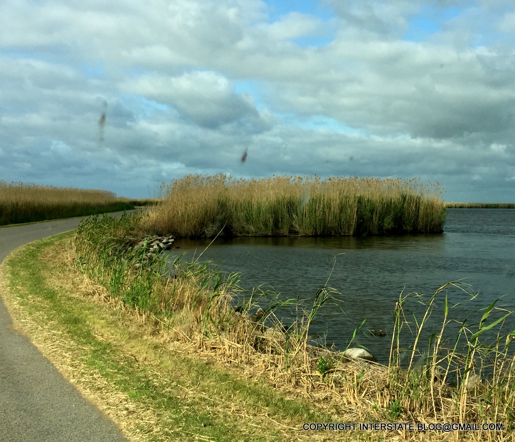
Most of the park is thickly wooded, and in its post-logging natural state, although they did clear an area to add a second man-made lake, called Lake Dabney, after former TPWD director Walt Dabney
Part of my purpose for this trip was to not road-test, but rather off-road-test, my folding bike.
Conditions were extremely wet and Peach Creek (in the background) was running very high.  But the bike took the rough conditions without complaint.
Extremely wet, I said.  I had to walk the bike through numerous areas to keep from tearing the place up.  
Amen to that.  Advisory courtesy of the Greater Houston Off Road Biking Association.  
I'm going to intersperse a few macro shots for interest.
Bluebonnets around Lake Dabney.  
The dog and I struck out along Five Mile Road for points south, including Lake Isabel, an old logging reservoir that has been allowed to naturalize.  
I should say, the overjoyed, deliriously happy dog.  Nothing pleases her quite like these kinds of hikes.  
They don't call it Five Mile Road for nothing.  This park is basically the only public land within an hour of my house where I can hike and/or bike and actually get tired.  It's the only park that's large enough.  Round trip from our campsite to Lake Isabel is 9 miles.  
There's a good way to not lose track of your bike - have it be the focal point in many photographs.
I had another motive for this trip, and that was to try out a twenty dollar camping hammock that I'd bought at Cabela's.  It's a low-ended model obviously, but I wanted to try it in order to help narrow down what I'd really like to see in such a device.
I'm partial to Mayan hammocks, in which users lie perpendicular to the long axis.  But I don't know if anyone makes such a thing in an ultralight camping style.
There's a practical purpose with these, as well as the enjoyment factor.  Hiking in hot weather can cause water retention - bloating, essentially.  Taking a rest and elevating the feet like this can help to restore fluid equilibrium.
I said "hiking in hot weather" because, in mid-April, temperatures are already in the mid-80's.  My father walked my land in Canada a few days ago and reported that there's still an 8-inch snow pack remaining (we're trying to get survey lines cut but that requires bare ground).  But we in Houston are already into the cusp of viability for trips like I'm describing here.  In a few more weeks, it will be far too hot for strenuous outdoor exercise.
The impossible greenness of being, as expressed by bald cypress trees.  They are the greenest things around when they leaf out in spring. 
Unfortunately what you don't get with this picture below is the corresponding sound track:  The birds singing, the frogs croaking, the crickets chirping.
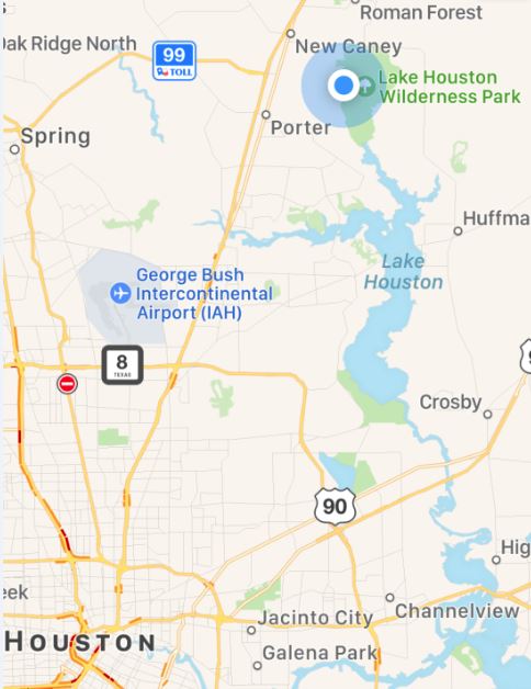
Mercifully, you also don't get to hear the occasional A380 screaming at low altitude overhead - this park is only 13 miles north of Bush Intercontinental Airport with its 43 million annual passengers, so air traffic can get interesting at times.  But thankfully, each vectoring cycle does not last very long (the controllers rotate the flight lines so that no one area receives a disproportionate share of the noise).  

These were blooming all along Five Mile Road.  I don't know what they are.
Our dog was a rescue and we don't have definite information on how old she is, but we know she has to be at least 8 years old, and she could be significantly older than that.  We are at the point of her age where we are very careful not to work her too hard.  She is very fit, but we have to travel fairly slowly and have periodic rest stops in the shade.
Here she is 7 miles into the 9 mile round trip.  This was a rare pose, however.  She did not want to be still and rest.  She was too excited to be on this trek.  
I had intended to do more testing of our van's new lithium battery system on this trip, but what ended up happening instead is that I mostly relaxed and enjoyed it, blowing off every other responsibility for 48 hours.
Camp site view from my rear door.  It's a bit fuzzy because it was taken through the noseeum screen. 
The next morning, we set off down the newly-named Ameri Trail that now extends southward along Caney Creek, where no state park trail ever existed previously, so that part of the park was brand new to us.  Notice I said, "next morning".  Temps fell to the low 60's overnight, which in Houston is roughly on par with hell freezing over.  But the day broke in full sunshine, and we were the first ones down the trail that day, so do you know what that means?
Perfect conditions for snakes:  Cool night, sunny morning, nobody else on the path.  Our dog is trail-trained and spends a lot of time behaving well as an off-leash companion.  But on this morning, I'd had the good sense to keep her leashed and close to me the whole way down this trail, because this is what greeted us.  Such an encounter was inevitable. 
You might miss such a critter, if all you saw was that pose above.  He blends in very well with his surroundings.  But get close enough, and what you'll see is a bit more distinctive.
Say cheese. 
The cottonmouth, aka water moccasin, is one of our Big Three, with the other two being rattlesnake and southern copperhead.  My least favorite is the copperhead.  With the other two, at least you might receive a warning, either visual or auditory.  A copperhead will simply strike without announcing itself.
Keeping the dog very close while resting.  No dog can survive a strike by any of the Big Three. 
A dog in the lap is a first-class ticket to general fawning and ham sandwich behavior.  Go ahead - show me your unabashed dogness.  And who cares if you buried your snout in the sand?  You clearly do not.   
The lower river trail is unprecedented - passing out of the Peach Creek sub-watershed and into the Caney Creek floodplain, the scene scales up accordingly.
Higher, wider, deeper.
There were some enormous point bars, such as this one.
Pure white sand, mostly quartz.


Of course, the Big Three are not the only reptiles we have to worry about around here.
Alligator tracks were everywhere, although they were mostly small.  But gators can (and do) take dogs when they get an opportunity. 
I returned home just as all hell was beginning to break loose on Houston's freeways for the long Easter weekend.  I'll remain comfortably holed up at home while much of the rest of the city waits in line for access to the likes of what I just departed.  Literally so - as I was leaving the park around noon, cars were already lined up from the entrance gate back to F.M. 1485.

And so the sun sets on yet another extremely fast (48 hours) but wonderful trip.
We'll be back.  During non-peak times when the crowds are not present, that is.