Showing posts with label CONNECTIVITY. Show all posts

Friday, February 8, 2019

PSA - AT&T MOBLEY CELLULAR DEVICE FRAUD

OK, I’m going to describe the facts of our fraud experience as succinctly as I can, in a timeline format (all dates 2019).

TL;DR – Incredibly strong circumstantial evidence suggests that my husband got frauded during the purchase of an AT&T Mobley device which is currently being offered at a promotional price.  AT&T has voided over $2,000 in scam charges to his account, but we don’t know how much of my husband’s personal information has been compromised in this process.  I advise Mobley owners to watch their own AT&T accounts carefully for evidence of this type of fraud.  It’s not the Mobley device itself that is the locus of this scam – the scammers are apparently adding unauthorized additional lines to AT&T accounts at the same time as they are adding the legitimate Mobley lines.  And then they rack up extreme charges on those additional lines very quickly, knowing that they are going to be detected and shut down soon enough.  We have no idea how widespread this fraud is.

DETAILS (all dates are 2019)

(1) On Thursday January 31, my husband went through the contractual process of ordering a Mobley for inclusion on his AT&T cellular account.  This is a popular cellular internet device used by vehicle owners.  You can read about the deal on this Sprinter Forum post, for example (and there are many others).

(2) Our Mobley device was shipped on Tuesday February 5.

(3) The Mobley was delivered to our home in Texas on Wednesday February 6.  The phone number associated with our Mobley is 409-204-9xxx (x’s for our privacy).

(4) Due to our work schedules, we could not activate our new Mobley right away.  We set it aside to deal with it on the coming weekend.

(5) On the morning of Friday February 8 (i.e., today), my husband received two text messages from AT&T (from the real AT&T - not from a scammer) telling him that he owed in excess of $1,000 in international roaming charges on each of two cellular lines on his account.  The numbers of those two lines were 409-204-9284 and 409-204-9285.  Note that they are almost sequential to the number that was legitimately issued in conjunction with our Mobley.

(6) Upon contacting AT&T, my husband was told that “someone” working “online” had fraudulently added these additional two lines to his account on February 4, the day before our Mobley shipped (and I bet this unauthorized addition occurred at the exact same time that our Mobley hardware device was configured).  AT&T voided those other two lines with the excessive charges, placing the SIM numbers on a global blacklist.

(7) AT&T revealed no further details about this fraud.

In my opinion, the circumstantial evidence supports the conclusion that the Mobley sellers frauded my husband - that circumstantial evidence is *overwhelming*.  The timeline is to the day, and the cell numbers are almost exactly sequential!!!  Duh!!

(8) My husband now has to monitor his credit rating etc. to ensure that no further breaches occur going forward.  It’s not clear how much of his personal data the Mobley sellers have accessed at this point.  Clearly, they got hold of enough information to transact thousands of dollars of scam in his name before they were shut down.

Good luck to you fellow Mobley owners.

Too late for us, hopefully not for you. 
I love this meme below - good question!


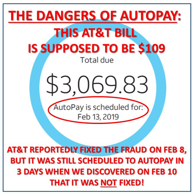
EDIT 20190211 - AT&T told my husband on Feb 8, 2019 that the fraud was resolved.  But when he logged in and re-checked on Feb 10, the charges were still there.  Worse, they would have autodrafted in another 3 days if he hadn't stopped that from happening.

No more autodraft!!  It's too dangerous, obviously!  If the autodraft of these frauded charges had gone through, our mortgage payment might have bounded, and then it would have been goodbye credit score.
AT&T forum thread on this topic:
https://forums.att.com/t5/Wireless-Account/Mobley-fraud-please-protect-yourself/m-p/5804727

EDIT:  I'm just going to leave this update here.  This says it all.


Sunday, April 1, 2018

EVALUATING CELLULAR CONNECTIVITY POTENTIAL

This post is a one-off published in the hopes that someone will raise a hand and tell me what I'm doing wrong, resource-wise and procedure-wise.
It wasn't working for us:
That white object extending upward from the rear of the vehicle is a Wilson Yagi directional antenna pointed toward a known (i.e., location-published) cellular source and cabled into the market's best booster which ultimately received absolutely nothing in the way of usable signal from this exercise and investment. 
After re-reading a couple of cellular troubleshooting forum threads, including this one in which the merits of this directional antenna are debated, my husband and I decided to get down to brass tacks and see if we could begin constraining the question with some actual computations, just as a first measure.

We know that cellular transmission functions largely according to line of sight principles.  There are some diffraction and reflection and other effects incorporated into the mix, but line of sight is the best bet, particularly as distances from the tower increase.

Tower details are public information and are published in both the United States and Canada.  The same is true of topography.  Theoretically, then, it should be a simple matter to determine a priori whether line of sight exists at any given location.  And here's the endgame:  If line of sight does not exist, how tall would a user's antenna mast need to be in order to achieve it? 

I'm primarily interested in determining these facts with precision within the context of a property that we own in rural eastern Canada.  However, for various reasons I will omit for brevity, that is a more complex determination, so I thought I would start off with a simple example where I've experienced cellular signal failure - Monahans Sandhills State Park in Texas.
It's a unique environment where the unprecedented small-scale topographic features play hell with connectivity.  This is an aerial photo of the camping loop where I stayed.  
Sand-bogged?! 
I'd like to coin a new term:  Cell-bogged.  
The Sandhills are particularly frustrating place to to get cell-bogged because we know that so many towers are nearby, both in the City of Monahans to the west and throughout the Midland-Odessa metro area to the east.
Good grief.  Starving in the midst of plenty.
Screengrabbed from Antennasearch.com 
So here's the basic procedure for making this determination.

You can see on the map above that there is one tower north of Monahans that is due west of the state park's campground.  I chose that one upon which to base this analysis.  Here are the stats on that tower according to Antennasearch.

This is where Hillmap comes in.  This blog post by the site's creators describes how to use Hillmap, but I didn't find any reference to the source data, and that's important, as we shall see below.

Here's a close-up of that tower's location on Antennasearch.

And here's the same close-up on Hillmap.
The blue line is tracing eastward toward the camp site.
For those of you not familiar with Texas, all those squares are drill sites.  This area is within the Permian Basin, an incredibly productive oil and gas reservoir.  
You can see from those two images above that I'm clearly assessing the same feature via Hillmap as I'm viewing on Antennasearch.

Now, here's a summary of the resulting topographic profile between this particular tower and the referenced camp site (map and resulting topographic profile produced by Hillmap, as annotated by me):

Tap this image to expand for clarity. 
Obviously we have major database problems here.  Just for starters, the two websites are in significant disagreement regarding the elevation of the land surface upon which the referenced tower was constructed.  That part of it should not be rocket science, but I can't determine the source of the discrepancy from the information that is readily available.  I will note that the tower in question was reportedly constructed in 1992.  That predated the commercial availability of high-quality GPS services, and maybe the available elevation data were much poorer back then - I don't know.

Hillmap was designed primarily as a backcountry hiking reference.  High degrees of accuracy are not necessarily needed for the fulfillment of their mission.  Again, I didn't find a statement regarding the source of their baseline elevation data.

I do realize that I've predicated this assessment on one tower that I wasn't able to confirm in the field as my actual source tower.  There are other factors that can influence line of sight, such as, the position on the tower of the cellular equipment.  The higher up a tower, the more expensive the placement.  Just because a tower is stated as 2,972 feet tall does not mean that the equipment itself has been placed on or near that height.  My carrier is the cellular giant Verizon, though, and I would expect their equipment to be commanding premium spots on towers.

Lastly, it's important to incorporate ground truth into any assessment such as this.  The ground truth in this case suggests that there is not necessarily sufficient resolution in the Hillmap database to accurately reflect fine-scale reality.  Here's a view to the west with my rig visible at intermediate range - in other words, looking generally in the direction of the referenced tower.  The highly-localized topography suggests that the rig may indeed fail where line of sight is concerned - there's a large sand hill to the west of it.
The camp sites are at the bottom of a sandy bowl. 
I picked this location for this blog analysis because the distinction between cell-bogged and cell-enabled was so clear.  All I needed to do to get good reception was trudge up to the top of the sand dune from which this photo was taken.  At that point, I was clearly line-of-sight.

In sooth, we need better data than what I've shown here if we are to do this type of analysis with accuracy sufficient to justify purchase decisions (which antenna, which mast, etc.).  If anyone has any source material suggestions or procedures that are superior to what I've presented here, please email me via interstate.blog -at- gmail. Thanks, and I will update this post in the future if I identify better evaluation methods.
My non-sand-bogged pooch enjoying the Monahans dunes at sunset.