A few pics here to wrap up the scenic part of this discourse, and then I will follow with a "lessons learned" blog post.
Can you spot the Sprinter in this picture? It parks quite nicely in regular-sized spaces when the tail is tucked back behind the parking space. Franeytrailhead, Cape Breton Highlands National Park.
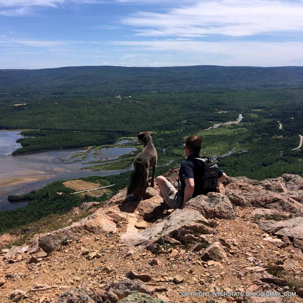
Franey is the type of trail that I wish I could hike every Saturday morning, just for the exercise, but at a minimum, we do the 5 to 6 mile mountain loop every time we are in the area. This was the one time I did not take my DSLR camera with me. Lo and behold, we discovered that Parks Canada had cleared out the surrounding trees such that the full regional view was finally attainable. This type of clearing had not occurred in anyone's memory in at least 30 or 40 years (we spoke with other climbers at the top). My luck! No good camera! Just the iPhone.
The sapphire blue of the ocean off this coastline is my absolute favorite color. I even bought these hiking boots because they had that color in them. Of course, that was many rough miles ago, and now mostly what's visible is dirt rather than the original blue.
The Clyburn Valley is also on full display from Franey Mountain.
This year, we really wanted to do another local hike called the Kauzmann Trail, but it turned out to be the one time that the back roads ended up defeating us.
The shadows make it a bit difficult to see, but there's a wash-out in the middle of this access road. At our lowest point, we have 5 inches of clearance with the Interstate because of the way the engine exhaust was re-routed around the generator. Furthermore, the Interstate is longer than the road is wide, so there's no turning around once one gets into a place like this - backing out is required. We chose not to risk damaging the vehicle in such a remote location, and gave up on this hike.
We therefore ended up revisiting a little known peak informally called Tenerife, which we had discovered only the year before.
She looks brave in this photo, but our dog actually disliked this hike intensely. It was too steep and treacherous for her, and she kept inserting herself between my legs as I was trying to hike, which caused me no end of laughter.
To the left of the dog is a cleared oblong field at the base of the mountain. To the left of that is a small parking area. A spec of light color in that parking lot is our Interstate. Very small, isn't it? This is a tough hike, not for the faint of heart (or body).
The winds are so strong and so continuous on top of Tenerife that the most exposed trees have branches growing on only one side.
We also hiked to the top of Broad Cove Mountain, which is a much less challenging trail. That's Warren Lake visible below and we usually hike around it also, but...
...an unprecedented development forced us to end our mountain hiking earlier than planned.
Parks Canada closed the eastern half of the park due to elevated fire danger.
For me, the ideal vacation is all about exercise, so this was a bummer.
At least I managed to get some fries and gravy before everything shut down. This is a local delicacy and don't even talk to me about poutine - I can't stand that stuff. This is the regional variant - usually turkey gravy, with lots of white vinegar. Love it.
With the park closed, we set off down the Cabot Trail for the long, long, LONG drive back to Houston.
-- To be continued under the heading Lessons Learned. --
My title should really read "Sydney NS to Ingonish NS by way of Gabarus NS". Here are a few more pics of this journey.
The village of Gabarus, with the harbor as seen from one of the public rights of way. Yet another picturesque old fishing village.
My personal favorite pic of this area doesn't show quite that same level of development, however.
In fact, it doesn't show any development at all. Somewhere between Gabarus and the similar nearby fishing village of Fourchu, I had bought some waterfront acreage more than 20 years ago. We tent-camped on it last year after flying up and paying excess airline baggage fees for our camping equipment, but this was the first time we had ever occupied the land in our Interstate. Initially, I wasn't even sure that we could get the low-clearance Interstate down the old private road leading into it, but with careful driving, it did prove to be possible.
A few pics of this wilderness property, including some macro shots.
I believe that's a Chanterellemushroom, although I wouldn't bet my life on it.
I don't know what these are, but they're cute.
Also cute.
Part of my land is actually low and wetland-y, hence the mushrooms and ferns.
I said I "own" the land, but a more accurate term is "claim". Or perhaps "pay taxes on" would be even more precise! Twenty-odd years ago when I first acquired the property, I used to think, "Somehow all these beach rocks have a 'my-ness' component to them."
Sunset over "my" cove.
After a rare overnight on my own land, we did a little exploring up and down the coast. The area is in a bit of existential limbo (in my view) because of the way the government has defined the public lands that make up the unique ecosystem that is now called the Gabarus Wilderness Area.
Tap to expand - excerpt from the government website. They simultaneously seem to discourage access to this area (by leaving the assets "unmanaged" and thus quite rough in places) but neither do they prohibit access. They simply state that it can be accessed, albeit in a rather uncontrolled manner.
I had hiked the Gull Cove trail when I was a child, and given that there were unusually strong southwest winds when we were in the area, we decided to brave the broken-down boardwalks and muddy trail ruts (see this blog postregarding waterproof floor mats for the Interstate) for a hike through this area. One advantage of a "no managed trail" outdoor venue is that there was nobody else on it, even though we were there on a Saturday afternoon in mid-summer.
The pic shown directly below was taken approximately at the location shown by the arrow. You can see why this coastal destination would be a good choice in conditions of extremely strong southwest winds.
Miles of coastline all to ourselves to enjoy. And the wind on our backs. Very peaceful.
The pile of rubble in the foreground shows what we assume to have been the former foundation area. After being moved, the lighthouse was repaired and repainted (five coats!). It is still a working aid to navigation. Although GPS electronic locator equipment is now standard equipment, fishermen still rely in part on physical confirmation via triangulation between this and another local beacon.
With its horizontal garnet stripe and general configuration, I may never look at our Interstate again without seeing... a stylized lighthouse.
The more I looked at the Interstate, the more I could see the echoes. Even the tapered body shape and rear doors seemed to mimic the general lighthouse design.
Due to the unusual weather pattern (which included the strong southwest winds), and the cloud formations were pretty amazing at sunset.
The little lighthouse that could, surrounded by multiple layers of clouds, all very dynamic and unstable.
We returned to Sydney briefly before striking out for parts north.
Along the way, we had several local meals at nonprofit venues. Much of this sparsely-populated area cannot sustain conventional restaurants, and so fundraiser meals are a frequently offered by community groups (and in fact they are offered even where the population density does support restaurants). This was a traditional Nova Scotia salt cod dinner served by a local Legion. We also had a breakfast served by a local church. Last year we attended a phenomenal potluck at a local volunteer fire hall. All one has to do while traveling is watch for the signs advertising these feasts, as they are very common.
Our destination of Ingonish is accessed via the world-famous Cabot Trail, which is long overdue for replacement in some locations.
This section of the Cabot Trailpre-dates me, and I'm over half a century old. They are working on it, but it's extremely difficult to drive an Interstate over the likes of this. In some locations, I could not exceed 30 mph. Furthermore with the edges of the road in total collapse, I had to treat it as a one-lane road here and there. Passenger cars have an easier time with the likes of this.
Our dog certainly was pleased to get a break from the rough roads.
Continuing on to Ingonish, we were again greeted by continuing remarkable weather in the form of dualing air masses from the south and north (there was even a tornado warning for part of Cape Breton Island, which is extremely rare for a location this far north).
Ingonish harbor near sunset. This pic was taken with an iPhone.
Our first night in Ingonish in the Interstate was extremely comfortable and peaceful, as it tends to be a bit cooler the farther north one travels in Cape Breton.
Crashed-out doggie, resting up for near-future adventures.
We gave new personal meaning to the phrase "run for the border" when we decided to travel from our home in greater Houston to Nova Scotia in late July.
I think this covers all the roads we took, but some of them are definitely a blur in my memory. It was a long, long, LONG drive.
Here's a pictorial commentary of the first leg of this adventure.
When we told folks that we did a 2,492-mile run in just 3.5 days, the common response was, "That's fast!" Yes, and the reason is that it was too danged hot to hang around the south. Our first overnight was in Oak Mountain State Park outside of Birmingham, Alabama, so that we could leave one of the back doors of the Interstate open for a bit of ventilation. Even with that, I don't think the temperature inside the truck fell below about 78.
Fortunately we only had one really hot night. And once we got out of the Deep South, I didn't care where we were staying - I just enjoyed the cooler temperatures.
Crackerdocking on the second night, temp around 70. Bliss to a couple of reverse snowbirds.
The Shenandoah Valley - always the scenic highlight of the American portion of this trip.
We had good travel weather but the interstate highway system seems to deteriorate further with each passing year. It's a mystery to me how we could pay for this system in the 1950's when money was so much scarcer, but we can't even seem to maintain it today when our society has wealth beyond anyone's initial imagination.
Even though we avoided major metro areas, we still ran into horrific congestion, one-lane freeway segments and long wait times. I took a picture of this idiot who literally ran us off the road about 45 minutes south of Scranton, took a picture so that I could report him later on.
The worst portion of this trip was crossing the Hudson River in New York, well north of New York City, where it was about an hour's delay getting through a toll booth that cost a whopping $1.50. I would have gladly given them $15 if we could have expedited the booth. Where is the sense in delaying thousands of people for an hour apiece just to collect $1.50 from each of them?! That kind of nonsense represents a level of bureaucratic dysfunction that's almost beyond comprehension.
They had electronic tolling which they call EZ Pass but we had to get in the cash line because EZ Pass does not talk to EZ Tag, which is our Texas tolling system.
Our intention was to stop at Dysart's truck stop on the third night such that we were there in time for dinner, but all this needless congestion delayed us by so much that we ended up pulling off in Portland Maine to eat dinner inside our Interstate.
When what to my wondering eyes did appear but the largest Whole Foods I've ever seen. In Portland Maine of all places (it's a Texas company, so I thought I'd seen it all. Apparently not.
I do not like driving after dark, especially in bear and moose country. But nevertheless we proceeded about 2 hours farther north to Dysart's so we could be there for breakfast. I wasn't prepared to miss Dysart's dinner AND breakfast!
Dysart's at dawn, lined up with the big boys.
It's a full-service truck stop with home-made food. We ate, had showers, got propane (a lot of propane - our fridge had chewed through 3.8 gallons trying to stay cool while in the Deep South), and dumped tanks.
From there it was a short run to the border, literally.
In Texas, we are mostly familiar with the Mexican border. This one looks a whole lot different!
The moment we were waiting for, literally, across days of other moments:
We arrived late afternoon, in time for a long sunset walk on the beach.
Parrsboro sits on the Bay of Fundy with its "highest tides in the world" claim to fame, and tides in this vicinity are about 40 feet. Here, The Engineer was timing the advancing water (his feet were submerged in 90 seconds).
Spectacular sunset. That turtle-shaped mass in the distance, left of center, is Partridge Island, which we planned to hike the next day.
After a peaceful night in the campground, we decided to spend some non-driving time exploring the town. Parrsboro is well-known for its annual Rockhound Roundup, which is how I first came to know the place in 1977. It is also home to the Fundy Geological Museum.
Things have changed momentously in the past 40 years! When I first saw this museum, it was a tiny little hole in the wall struggling to get off the ground. Now it's a world-class facility with many interactive displays. I wonder what would have happened if someone had tried to explain "selfie" to us in 1977?
People like me used to be called super-nerds. Now they make museums showcasing our career field. Who would have guessed this? The caption on the display says "Most geological work happens in the lab". And there's a display window through which people can watch said work. Go figure.
We ate lunch at the BlackRock Bistroin Parrsboro while waiting for the tide to recede enough for us to hike over and around Partridge Island.
We arrived to see the shoreline foaming like the world's largest soda bottle. In some places, the beach is so steep and the tide recedes with such velocity that it sucks air down into the coarse gravel. The air then re-liberates itself a short distance off the shore, for a bizarre effervescent effect.
Close-up of the surreal tidal bubbles.
We first hiked up to the top of the island.
In my day, people were much less "eco" but much more "engaged". These days it seems to be more about saying what you are instead of being what you are. When I was young, we never claimed any special politically-correct status such as "eco", but we lived and breathed the Nova Scotian wilderness the way I almost never see people doing these days. But a lot of people sure seem to talk a good talk. And sign a good sign.
After we got done climbing on top of Partridge Island, we walked about 80% around it. It used to be possible to go the entire distance via the beach, but there's been a lot of erosion, and after a great deal of boulder-dashing, we had to bush-whack back up to the top of the island and take the main trail back down again. But we saw some great coastline up close and personally. Engaged-style.
Given that high-speed internet is much better in Canada than in the U.S., I was even able to upload this mini-vid of our parking spot on Partridge Island.
^^ What makes a 6,000-mile round trip worthwhile by camper van is exactly that kind of solitude. It cannot be achieved in our part of the United States. Not like that.
The next morning, we struck out for my hometown of Sydney.
A Nova Scotia travelogue would not be complete without at least one token lighthouse shot. This was the Five Islands lighthouse.
I had forgotten that camper vans are more popular in Canada than they are in the United States. Here are a few of those we saw en route to Sydney.
I saw more in three hours than I've seen in the past two years in the U.S.
We arrived in Sydney in good form and had our first family conflab inside our Interstate. Here's the next morning's sunrise from my side of the Interstate (view from my bed).